Intoduction to Photogrammetry
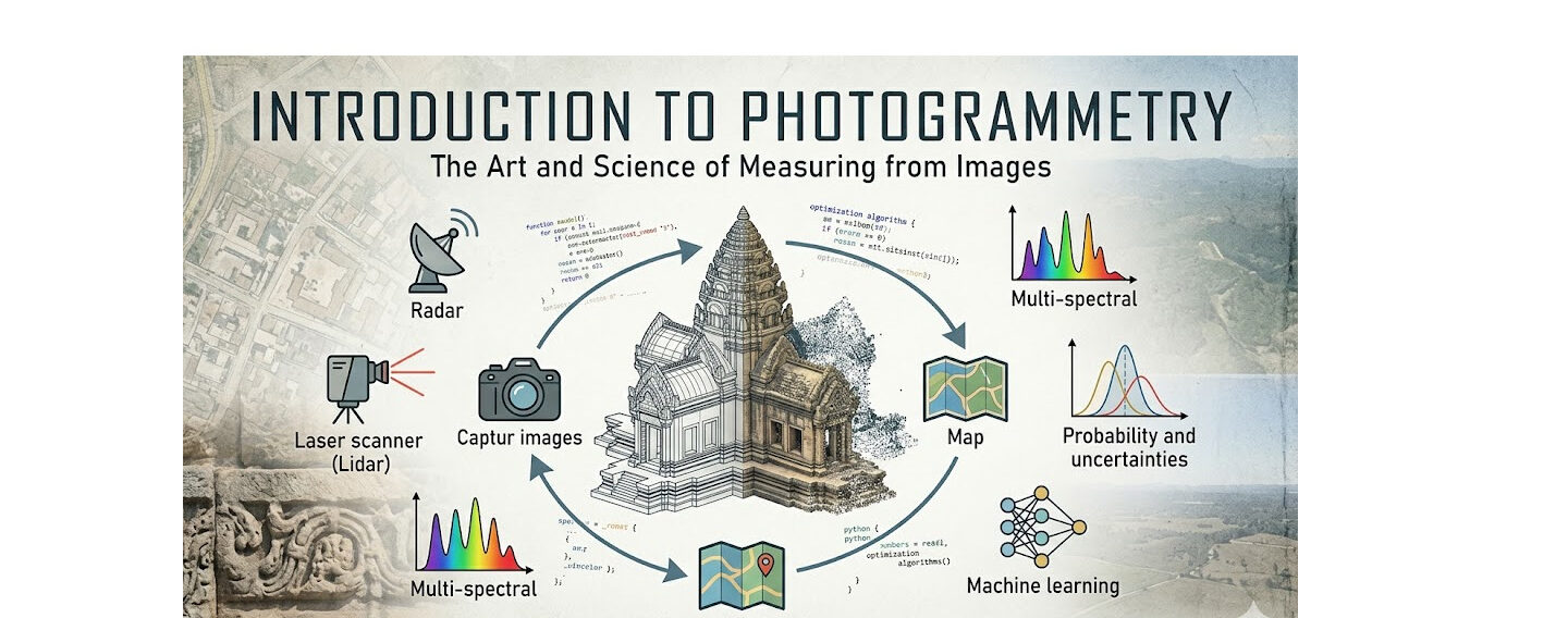
Photogrammetry is both an art and a science focused on extracting meaningful information from images. This includes geometric measurements, radiometric properties, classification data, and even the uncertainties associated with them. At its core, photogrammetry transforms visual data into precise, measurable insights using advanced processing techniques and computational methods.
Images are the primary data source in photogrammetry and can be categorized based on their distance from the subject. These categories typically include spatial, aerial, and short-range imagery. However, modern photogrammetry is not limited to traditional images alone. It also incorporates diverse data types such as point clouds, radar measurements, laser scans, and multi- or hyperspectral imagery, all of which contribute to a richer and more comprehensive analysis.
The field is highly interdisciplinary, intersecting with several areas of science and technology. A solid understanding of statistics and probability is essential for interpreting uncertainties in measurements. Optimization techniques help estimate parameters efficiently, while image processing plays a crucial role in extracting features and generating point clouds. Additionally, machine learning and neural networks are increasingly used to identify patterns, and electronics support the design of measurement systems.
This work is the result of years of research and teaching in photogrammetry and computer vision. It is designed to simplify complex concepts and present them in an accessible manner, particularly for students. The material follows a structured approach—starting with fundamental principles and gradually introducing more advanced topics, along with partial implementation examples using programming tools such as Python.
Some of the methods presented are experimental and developed specifically for educational purposes. While they may not always represent the most computationally efficient solutions, they are intended to provide deeper conceptual understanding, which is a key objective of this work.
Photogrammetry continues to evolve as a field driven by collaboration and shared knowledge. Contributions from researchers and practitioners help refine methodologies and advance the discipline. This resource aims to support that ongoing development by offering a clear and approachable foundation for learners worldwide.
List of published topics so far:
You can find description to Euler Angles & Rotation Matrices here. A brief descirption about 2D Conformal Transformation is written in this post. Affine and Projective Transformations and their role in Photogrammetry is discussed here. Then an important transformation called projective is inclusively introduced. You can also find some material regarding Interior Orientation.
University of Eastern Finland (UEF) has announced the release of the initial version of its Geoportal, a dynamic platform designed to improve access, management, and sharing of geospatial data. This launch marks a significant milestone in UEF’s efforts to create a collaborative environment for researchers, students, and project teams working with spatial datasets.
The newly published Geoportal focuses on enhancing user interaction, data accessibility, and platform efficiency. Among the key features already implemented are a robust user access and sharing mechanism, a “Shared Projects” page, group-based upload limits, a dedicated user settings page, and an integrated feedback system.
Key Features Include:
- User Access and Sharing: Project creators can share their work with specific users, groups, or the public, with options for time-limited access. Users can also request access to projects, with requests managed directly through personal dashboards.
- Shared Projects Page: This feature allows users to browse all projects they have permission to access, view project metadata, and submit access requests seamlessly.
- Group-Based Upload Limits: Users’ upload capabilities are managed by group-assigned limits, ensuring fair and efficient use of storage resources.
- User Settings Page: The platform provides an overview of each user’s projects, group memberships, assigned storage, and usage, enabling better self-management.
- Feedback Mechanism: Users can submit feedback directly to the development team, supporting continuous improvement and alignment with user needs.
In addition, UEF is actively developing features for mass email notifications and automated dataset publishing. The mass email system will keep users informed about updates, new features, and system changes, while the automated publishing functionality will streamline the sharing of raster and vector datasets through GeoServer.
“The launch of the UEF Geoportal represents a major step forward in providing a user-friendly, collaborative platform for geospatial data management,” said the project team. “With these initial features, we are not only meeting current user needs but also laying the foundation for future scalability and enhanced operational efficiency.”
The Geoportal is expected to serve as a central hub for UEF researchers and collaborators, promoting transparency, accessibility, and teamwork in the management of geospatial data.